Bridging the knowledge gaps: expanding Wikimedia content from Canada’s remote North
Article written by OhanaUnited – Activity supported by Wikimedia Canada’s micro grant program
During the video call with northern Canadian editors and readers at the Toronto Wikipedia Day celebration, the conversation briefly touched on the systemic bias on English Wikipedia. Since the United States of America has roughly 10 times of the Canadian population, American topics dominate English Wikipedia and oftentimes American editors write about Canadian topic pages from an American perspective. In Canadian pages, there remains substantial gap for contents about women, remote and isolated communities, wilderness areas, Northern and Arctic regions of Canada and Indigenous groups on Wikipedia. This discrepancy is broader for other Wikimedia contents such as photos on Wikimedia Commons, entries in Wikidata and travel pages in Wikivoyage.
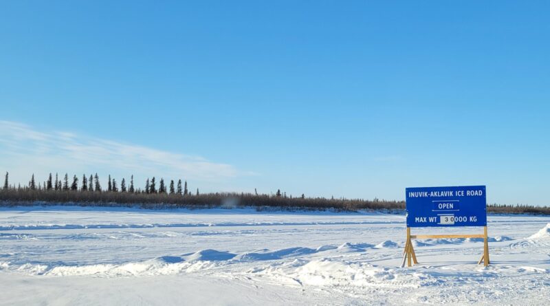
In late February, I was in Inuvik, Northwest Territories for event engagement with the Inuvialuit. While I was there, to take advantage of this opportunity, I drove to four Indigenous communities in the Inuvik Region: Aklavik, Inuvik, Fort McPherson and Tsiigehtchic, all within 24 hours. These communities are homes to predominantly the Inuvialuit and Gwichʼin. I took pictures on geographical features (e.g. water channels, tributaries, river mouths), local politicians, community infrastructure (e.g. hamlet office, police station, school, health centre), history (former Indian residential school sites) and transportation (airport, ice road). In the former Indian residential school site photos, I took particular care to accurately describe the structures of these schools were demolished and later replaced by other buildings built on the same plot of land. I also documented places of interest for Wikivoyage that would be beneficial to travellers, such as attractions, gift shop and hotels in remote communities. I added information about hotel and gas stations in Fort McPherson as it is the only community with accommodation, gasoline and diesel service within a 2.5-hour driving radius, improving the safety for travellers who use Wikivoyage as a travel guide.
My activity led to:
– 120 photos uploaded to Commons. 4 new Commons categories are created. Highlights include:
> 2 local politicians were photographed, including the mayor of Inuvik and the current commissioner of the Northwest Territories (equivalent to the Lieutenant Governor position for provinces)
> 26 geographical features that were identified as needing photos had their photos taking during my drive. They were uploaded to Commons and linked to their corresponding Wikidata entries
– 2 Wikivoyage pages were created (Aklavik and Fort McPherson) and another 3 Wikivoyage pages were improved (Inuvik, Dempster Highway and Tuktoyaktuk)
Unlike Toronto, taking pictures and uploading them to Commons in wilderness areas presented great challenges because the tools that I used to identify locations needing photos required constant internet connection. This was not very useful when I was on the ice road and without mobile internet for 2 hours! I only regained usable internet on my phone once my car approached the next community. Once I had internet, I regained the ability to use tools, lookup at the map and upload to Commons immediately after taking a photo in the community, minimizing mis-identification of buildings and geographic features in the process.
Since my activity area was above the Arctic Circle, the sunset time is early and the sunrise is late in winter relative to southern locations. This reduced the window for me to take photos in daytime. However, the benefit of this activity taking place in winter was the relative ease and speed to access waterways to take pictures of islands, peninsulas and channels by driving on the ice road. While this photo activity could take place in summer, boating would be much slower and would not reach as many places as driving on the ice roads.
One of the major issues I identified after returning home was the erroneous description for many Wikidata entries. Many of the items needing photos were water channels yet the Wikidata description identified them as peninsulas. This caused me to take a lot of pictures of peninsulas and islands when I should be focusing on the channels, tributaries and river mouths. Furthermore, in one particular instance, I drove 45 mins in search of a remote research station and weather station but could not find either, which I suspect was due to incorrect map location on Wikidata. In both cases, since there was no internet available, I could not look up online to verify the water channels nor the remote research and weather station locations. This highlighted the importance of having accurate Wikidata description and metadata of an item. Having offline access to tools or the ability to download an offline copy of a map with coordinates marked (currently not available) will better support similar types of work in the future. My activity highlighted the need for continued tool development to support contributions from remote and isolated areas.
Photo credit: Inuvik-Aklavik ice road – OhanaUnited – CC BY-SA 4.0